
Nothing inspires me more than the phrase “it can’t be done”. I’d come to this Phong Nha on the recommendation of several people only to be told that the one way to access the area’s unique natural features was on a paid tour. I was already frustrated that the prices here were two to three times anywhere else in Vietnam, when I was informed that I must also pay western prices for a tour.
The only low cost form of activity was the free bicycles offered by the hostel. That suited me fine as cycling is my favorite way to explore an area, but when I asked the front desk person how far it was to ride to the National Park entrance, he responded, “too far, about 15 miles”. I tried to explain that I was a proficient cyclist and that I could ride that distance in about an hour, but he just said it can’t be done. I decided right then that it would be done.
So many times in my life I’ve been given that answer. Most notably when I decided to hike the Maze section of Canyonlands National Park in Utah. We asked the ranger if we could complete a loop of a particular hike by climbing out of the canyon at the end of the hike. He said it couldn’t be done so we made a point of climbing in and out of the Maze every day of that trip.
The free bike offered was a single speed, which wasn’t too disheartening since I had taken my beach cruiser, back home, over multiple mountain passes; so after getting my tires fully inflated I headed down the road to the edge of town. Once I was out of the tourist area, I made a quick stop for food since I didn’t know what provisions would be available later. This turned out to be a prudent decision. It was breakfast time, and I joined several locals at a long table for a typical Asian breakfast: chicken noodle soup. For much of Asia this serves as lunch and dinner too.
It was another one of those experiences where, as I received my meal, all eyes were upon me, having rarely seen a foreigner eat outside the tourist zone. Little sniggers passed through their lips as the beads of sweat appeared upon my forehead, a result of the chilies used to spice the soup and possibly to kill any food borne toxins. They were doing their job, and while they didn’t kill me, they certainly made me feverish as my body attempted to cool itself through rapid evaporation.
Two bottles of water and many nods later, I said good bye to my hosts and got back on the road. Immediately after leaving the town I found myself riding through an emerald landscape of farms punctuated regularly by rock karst formations and followed on my left by a lazy green river. I determined that even if I didn’t make it to the national park, I would at least enjoy a beautiful ride in the country.
The road I was on turned out to be the original Ho Chi Minh highway and was heavily traveled by cars and trucks, so when I saw a little road off to the side, I decided to pull out my phone to see if it might be an alternative to the noisy highway. Google maps has been an excellent resource for my explorations. In many cases it has inspired me to go down an alley knowing that it won’t be a dead end. To be honest, I would do this even before the advent of Google maps, but I have certainly saved myself a lot of time with this introduction of technology to my exploits.
The frontage road was exactly what I was hoping for, and I was plunged into the lives of the locals trimming trees in front of their homes, tending to their livestock, drying fruit and leaves on wicker racks leaning against the fences in front of their homes. Children paraded down the street, and not a one of them let me get by without a wave and a shout of “hallo”! Again, I was the spectacle of the day, and I must have greeted by thirty people before returning to the main highway twenty minutes later.
Inspired by my first deviation, I looked again at my phone for another alternative to the highway. There were two gray lines on the map that looked like they would also reduce my overall distance by creating a shortcut between two highways I would have to travel to the park. I experinced a little trepidation as both of those gray lines tapered to a very light color which could indicate almost anything, but it certainly indicated something. I accidentally passed by the first line on my map because it turned out to be nothing more than a path of clay and mud, something I knew could not be traversed on anything other than a tractor, but the second road was a solid dirt path so I decided to give it a shot. It took me into an even more narrow valley of karst intrusions. This time there were no houses or children on bikes, and I began to wonder how much time my short cut was going to cost me.
Not too much later my path entered a village and I was greeted again, as well as followed, by children as I rode through. I reached a junction that was not on my map, and the parade of children tapered off as I took the right fork. That should have been my warning, but I saw the main highway not far in front of me so I pressed on, even as the path began to narrow. I passed the last few houses of the village when the now single track path I was on came to an abrupt end in a field. I could see the main highway just a hundred yards away but between me and the highway was the river that had been following me throughout the morning. I looked up and down the river and thought it odd that there was no crossing. Apparently, the locals prefered to keep this a remote village. While I was pondering what to do, an older woman passed me by, and as if she read my thoughts, she brought her hand up to her chest indicating, I assume, the depth of the river before me.
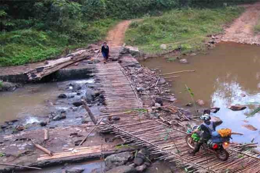
Referring to my map once again, I saw that I had gone the wrong direction at the fork and that I would have to backtrack to the little village in order to follow the gray line that I now hoped actually crossed the river. As impressive as it is that these roads were indicated on Google maps, I ran into a problem I have had with the app before. They don’t necessarily indicate if a road is closed or a bridge is under construction, which turned out to be the case when I again tried to cross the river. Fortunately, the construction was at a point that I could cross the river even though I had to carry my bike while balancing on wooden planks.
Having fjorded that obstacle, I continued riding until I came to a single lane suspension bridge that appeared to be the last link among my gray lines to the main highway. I had to wait to cross while a man came my direction with an ox, but soon I was back on the main highway. It was easy going after that, and I quickly realized that my shortcut had in fact cost me more time than it saved.
I was excited to pass beneath the gate that marked the entrance to the national park and was beginning to think it hadn’t been too bad when the road began to climb. It was slight at first, and I was able to ascend the hill even with my single speed town cruiser. The real challenge came in the last mile before the cave I wanted to visit as the road rose to a ten percent grade. In the best of circumstances, I may have been able to make the climb, but it had been raining the whole day before, and the road was covered in wet moss that caused my tires to slide out from beneath me. I decieded at that point that it would be prudent to walk the bike.
It wasn’t long before I arrived at the entrance to the cave, which was also gauntleted by food vendors so I decided to reward myself with a cup of coffee. Something I love about communal cultures is that they look after each other, so even though the first place I went didn’t have coffee, the gentleman yelled across the parking lot to another vendor who could provide it, and I was waved over. It turned out to be the local’s spot, and I enjoyed my coffee surrounded by motorcoach drivers who were smoking and playing cards as they waited for their tourists to visit the cave.
My ride to the cave had taken two hours, and the visit to the cave took two hours so I was right on track as far as time goes. I had told myself before I left town that if time allowed, I would do the entire park loop instead of just going out and back to the cave. The additional distance to do the loop was only a couple of miles, so I thought it would be nice to enjoy some new scenery, and I figured it wouldn’t take too long if it was anything like the the routed I’d experienced so far. It wasn’t.
Soon after departing the cave, the road began to climb again at a ten percent grade. I didn’t want to burn myself out so I got off and pushed my bike up the hill for about ten minutes before enjoying a long descent into another river valley that brought me to a crossroads of two highways. I was intrigued that, with a right turn, I could be in Laos in about an hour, but I thought better of it, particularly since I didn’t have a visa for that country, and took the left turn back towards town. I had expected this to be all downhill as I was now traveling in the same direction of the river that led to town. The detail I hadn’t considered, despite having visited two river caves in the area, is that rivers in this area flow through rocks, and roads do not, and I had to muscle through two more long climbs before the final downhill into town.
The downhill was every bit as steep as the climb leading up to it and a bit of a challenge for my coaster brakes so I did my best not to let the bike accelerate too much. At one point, a truck came up the hill at me, and I had to put my feet down to slow the bike enough so that I could get off the narrow road to let it pass. I was even more careful after that near miss, but it wasn’t long before the road finally flattened out, and I passed beneath the park exit.
About twenty minutes later, I was back in town congratulating myself with an overpriced glass of wine for once again doing what can’t be done.