
My mistake was in assuming that the women who informed me about the loop hike had actually just done it. You see, they’d passed me only twenty minutes earlier while I was enjoying a tamale from atop a rock above a dry creek bed. I met them on their return at an intersection which, on the map, appeared to be a loop. I asked if going either direction was the same, and they replied, “yes”. Since they’d only been 20 minutes ahead of me, I assumed that they had done the loop and that it had taken them 20 minutes. That mistake was on me. An hour later, I ended up back on the trail about 10 minutes further up from where they’d given me the directions.
The right fork that I’d taken followed a rocky riverbed and, at times, the trail actually was the riverbed. Several trails branched off, and after a couple attempts, I realized that they simply dead ended at viewpoints. I had to scramble down both times to get myself back to the riverbed, and after about 30 minutes, I managed to find the main trail, that led from the river canyon I was in, to the river canyon where I’d gotten directions from the two women.

I’d chosen the right fork because, on the map, it led past a viewpoint, and I thought since I’d come all that way, I should visit all the viewpoints. It wasn’t the grand vista I’d hoped for, and when I returned to the original trail, I realized I’d lost an hour. While that might not be a big deal on a shorter hike, I had calculated the hike I had planned could be as long as 6 hours. Now I’d just added an hour.
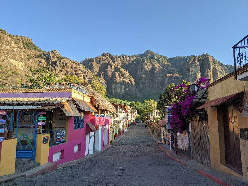
The main site to see in the village of Tepoztlan is a pyramid built upon the cliffs high above the town, and it was really the only thing to do since I’d arrived early enough the day before to see the rest of the village. I read the walk to the pyramid would take about 45 minutes so I looked into other options for the day.
According to the maps I looked at, there was a nice long trail that wove through the canyons created by the vaulted peaks of the mountains overshadowing the town. It indicated that there were several viewpoints and, towards the end, it would lead into the pyramid from the back side. There was little question that that would be the route I’d take. Based on the distance, I estimated 6 hours but, as often happens, I’d neglected to account for elevation.
The first third of the walk took the two hours I’d anticipated. I’d grabbed a tamale and some bread from the market on my way out of town and followed the road that led to the far side of the mountain range. It was primarily residential, and as I got further from town, the houses got bigger, eventually transforming into estates as I reached the furthest edge of the town.

The road then turned left and headed up a hill, entering a canyon between the towering cliffs. The road turned to a footpath that followed beside a dry riverbed, and I decided to enjoy the tamale while sitting on a large boulder under the shade of a tree, and that’s when the two women passed by.
That they’d represented the two trails as equal made me wonder whether they’d actually done the right fork. They were dressed as well-to-do women, and I found it hard to envision them doing the rock scrambles I’d had to do in their clean clothes and brand name running shoes.
Losing an hour so early into the walk was a concern, not only because it could make my day longer, but because it would prevent me from exploring any other interesting side tracks along the way. As it turned out, the second third of my six hour hike took four and a half hours. The trail climbed relentlessly out of the river canyon for about 1000 feet. I make no complaints. The views from the ridgeline were well worth the effort.

On one side, I could see the town where I began my trek. It was nestled within the crown of mountains that surrounded it, little white boxes lining the streets where dogs had chased me earlier in the day. On the other side, the canyon I’d just climbed out of with its numerous canyons divided by fingers of the mountain above.
All my senses were stimulated. I could smell the pine needles on the ground that had been baking in the afternoon heat. It immediately brought back memories of my times in the Sierra Nevada mountains of California. From above came the sound of wind blowing through the mesh of needles still clinging to the trees overhead. It was a euphoric moment, and I added the hike to my mental list of top five in my life.
I am bored without views. They are the reward I require for my exertion. If I’ve hiked and seen nothing but trees for hours, I am bored, but a ridge hike is the best for offering vistas at every turn. I took several pictures of the views on either side and continued to climb. At each break, I thought I’d gone as high as I would have to climb, but my assumption was continually challenged. At one point, I walked out onto an outcropping and startled several vultures into flight. You know you’re high when you’re looking down upon the wings of soaring birds.

I had a hope that I would be able to shorten the distance of my hike since not all the trails necessarily appear on the map, but looking at the gulf between my location and the ridge with the pyramid confirmed I would be disappointed so I continued to follow the trail as it worked towards the head of the canyon in front of me.
When I got to the trail junction indicated on the map, I had to double check. The route I was supposed to follow dropped rapidly to the base of a cliff at the head of the canyon. I stayed on the main path and found myself walking away from the direction I needed to head, so I returned to the junction and descended.

Of course my main concern was that I would have to make up all the elevation that I dropped to get to the bottom of the cliff or that the trail would eventually taper off into thick bush, but I was pleased to see that it continued to be well traveled. After hopping a couple downed trees and skirting across a rock slide, I eventually realized I had lost the main trail. This was indicated by the blue dot on my electronic map being well below the displayed trail.
It was clearly a traveled trail so I continued until I reached a spring not indicated on the map. It was well known by some people, however, as the concrete wall which was built to contain the water, had names carved into it. For a moment I feared that the trail would end there, and I would have to backtrack to my wrong turn, but I looked up to see a trail ascending steeply towards the ridgeline.

While I didn’t relish climbing again, that was the direction of the path I’d lost so I persevered another 30 minutes before reaching the ridge top. None of the paths I saw were indicated on my map, so I had to make a decision. At that point, I believe my age caught up with me. I was already 6 hours into a hike I’d expected to have completed by now. In fact, earlier, I had been imagining all the things I’d do when I got back early: a nap, a massage, maybe even a visit to the next town.
It was clear that none of those things was going to happen, and I chose to take the road that would lead most directly towards the town I’d hoped to stop at for lunch. The path descended steeply, and there were several options that branched off, but I continued with the most direct route down. Eventually I ended up in the middle of a cactus farm and moved as quickly as I could to the road on the other side lest I have to explain what I was doing in their farm.

Once on the main road into town, a pack of dogs decided to challenge me, but I resorted to my tried and true method of reaching down to pick up a rock, and they quickly scampered a way, yelping as if I’d actually thrown the rock at them.
I only call it the main road because that’s how it was indicated on my map, but nothing short of a four wheel drive vehicle would have the clearance to navigate the large boulders scattered about. I passed a couple of old women and asked them if they knew where I could get something to eat, and they directed me to the center of town. I shouldn’t have been surprised at the lack of offerings in this unremarkable town. I wondered why a village so close to a thriving town would not try to mimic the shops and restaurants, but maybe the village preferred to remain obscure.
I was not actually that hungry and decided I’d rather save my meal allowance for a big treat at the end of my hike. I was dehydrated, though, so I stepped into a restaurant and ordered a jamaica water, which is made from the jamaica flower and tastes like cranberry juice. Normally, I order a small, but I went for the full litre this time and managed to drink the whole thing in just a couple minutes.
I was so tired when I arrived in the town that I had been considering taking a cab or bus back, but when I looked up the estimated time on my walking app to return via hiking paths, it indicated only another hour and a half. I decided I could handle that, especially since the elevation view showed it to be all downhill.
The app didn’t lie; it was an easy stroll out of town on a relatively well established trail. To be sure, if you were to have navigated the trail with a vehicle, nothing but a jeep would help clear the large rocks and drop offs, but on foot, it was fairly easy. Given the width of the path, I figured this was in fact the original route to the town I’d discovered.
Eventually a path led off to the left. On the map, the path was indicated as the back way to the pyramid above the town of Tepoztlan and the birthplace of Quetzacoatl, the serpent god of the Aztecs. When I got to the junction of the trail that led from town below to the pyramid above, I opted to go right and skip yet another ascent that day. I knew there would be a fee to access the pyramid, and I couldn’t imagine any better views than from my vulture’s nest earlier in the afternoon, where I was able to look down on the pyramid.

It was still a steep challenging descent back to town. You are most likely to get injured when you are mentally and physically exhausted, and I paid as much attention to each foot placement as a drunk does trying to stay in his lane on the highway. I was surprised at the number of people headed up that late in the afternoon and began to question whether I should have visited the pyramid after all.
My decision to skip it was validated, however, when I reached the bottom of the hill and turned to see the sign indicating that the pyramid was closed to do Covid. I will say, I would have been really disappointed had I hiked all day to reach a closed pyramid, but since I had chosen not to go, and I’d enjoyed amazing views all day long, I didn’t care.
I plodded back to my hotel on autopilot, putting one foot in front of the other knowing my suffering would soon be over, but then I remembered I hadn’t yet paid the proprietor of my hotel. I’d promised to pay him when I returned, yet I’d forgotten to bring my ATM card which I needed to get enough cash to pay him.
Continued plodding, like a zombie, I headed down the hill again to the ATM. As expected, it was not open. Whenever you do a search for ATMs in Mexico, you always need to earmark at least 3 to choose from. One won’t take your card, one might have a line around the block, and in this case, the closest ATM was being serviced, and a guard with a shotgun communicated clearly that I should not approach any closer.
Fortunately, my second choice was open, there was no line, and my card actually worked. One more time, I climbed the hill to my hotel and paid the proprietor. I went upstairs to my room and put my feet up while I downed a couple Advil and chased it with equal liters of water.
After an hour, I decided a steak and whiskey were in order. For one last time, I headed down the hill to a bar I’d found the day before. Though it wasn’t the best steak I’d ever had, as is often the case when you’ve worked so hard to earn it, it was surprisingly good for Mexico, a country that usually pounds a steak to a centimeter in thickness. To my surprise, it was a full inch thick. They also had my favorite whiskey, which made a nice accompaniment to the view of the mountain range in front of me, whose ridge I’d spent the better part of the day on.
